The majority of the world’s urban growth takes place in informal neighborhoods constructed from makeshift materials on the edges of major cities. Residents of these areas often lack access to public services, but new mapping technology offers new possibilities for connecting them to urban infrastructure.
BOSTON – The future of urban planning may be in Brazil’s second-largest city. But it is not along Ipanema’s glittering waterfront, overlooked by some of the most expensive real estate in Latin America. Nor is it in the Centro district, refurbished for the 2016 Olympics and now the focus of a major urban regeneration plan. To glimpse the future of cities, travel past the Rodrigo de Freitas Lagoon until you reach the Jardim Botânico neighborhood, and then look to the hills, where the boundless Rocinha district is perched perilously on the slopes.
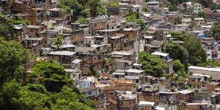
BOSTON – The future of urban planning may be in Brazil’s second-largest city. But it is not along Ipanema’s glittering waterfront, overlooked by some of the most expensive real estate in Latin America. Nor is it in the Centro district, refurbished for the 2016 Olympics and now the focus of a major urban regeneration plan. To glimpse the future of cities, travel past the Rodrigo de Freitas Lagoon until you reach the Jardim Botânico neighborhood, and then look to the hills, where the boundless Rocinha district is perched perilously on the slopes.